
To create an accurate sundial, latitude and longitude must be known. Using only household items, astronomical tables, and an accurate clock, I calculated the Woodland Polar Sundial’s coordinates from celestial observations made at the Paula Way Observatory.
Approximate latitude is not hard to determine; the altitude in degrees from horizontal to the North Star, Polaris, is very close to the latitude, since the declination of Polaris is only 0.65 degree from the North Pole. Watch Polaris for one night, repeating measurements of its altitude with an accurate sextant or inclinometer. You can download instructions for making an astrolabe, which is also a sophisticated inclinometer, on ShadowsPro. Take the highest elevation reading and the lowest, average them, and this will be very close to the elevation of the North Pole, which equals your local latitude. Atmospheric aberration need not be considered for latitudes over 30 degrees.
Longitude is more difficult, since one must know precise time, and one must take the Precession of the Equinoxes into account (see Topic “First Point of Aries” for explanation of precession and right ascension).
All the positions of the distant stars have been determined; many people over the last 400 years have put in a lot of cold, dark hours of work to accomplish this. Thus, the transit times of stars at a known location have been recorded with accuracy; have been catalogued; and are easily available, for example, from the U.S. Naval Observatory Astronomical Applications Department, aa.usno.navy.mil. A celestial transit (more properly called upper culmination) is the maximum altitude reached by a star or other celestial body in a 24 hour period at the local meridian. The transit of the sun occurs at solar noon each day. A more precise measurement of longitude can be made by using the point source of other, nocturnal, stars.
In 1850, a new telescope was installed at the Royal Observatory in Greenwich, England. Designed by the Astronomer Royal, George Airy, the Airy Transit Telescope was aligned along the north-south axis, and thus could only move up and down on its local meridian. When a star crossed this meridian, the exact time was recorded, and the exact elevation of the star was recorded, which, knowing the local latitude, could be converted into its angle above or below the celestial equator, which is its declination. This established the star’s (almost) fixed position coordinates in the celestial sphere: declination, analogous to latitude, and Right Ascension angular distance measured east from the First Point of Aries, analogous to longitude. If an observatory or ship knew these celestial coordinates, they could set clocks accurately if the knew their longitude, or compute their longitude if they knew accurate time and converted it to Greenwich sidereal time. Measurements were made from this instrument from 1850 to 1934. By 1884, two-thirds of ships at sea were using these star coordinate tables from Greenwich. In 1884, an international convention met in Washington, D.C., and agreed to set the Greenwich local meridian as the Prime Meridian.
As seen in Topic ” Sundial Calculations,” to calculate the position of the sun at a certain time, the sun’s declination, the sun’s elevation over the horizon, the observer’s latitude, and the hour angle (a measure of longitude) are needed. The sun’s declination changes rapidly, from -23.5 degrees to +23.5 degrees in six months, from solstice to solstice. Since the other stars are so distant, their declination and right ascension are almost fixed, changing by only a small amount over vast periods of time, due to their respective galaxies’ rotation and other very slight movement within their galaxies. The changes of the earth’s precession do need to be considered, but that is because we on earth are shifting OUR position, not that the star is moving. The declination of the star Fomalhaut was -29° 34’ 09” on 1/1/2010 and was -29° 30’ 57” on 1/1/2020, a difference of 3’ 12” or .053 degrees due to precession of the earth. This needs to be considered to accurately compute latitude. Since the earth is not a perfect sphere, this also needs to be considered to obtain an accurate measurement of latitude. Precession also changes right ascension, used to calculate longitude, as discussed below.
So, to calculate the position of night stars, all one needs are the star’s declination (analogous to latitude), its right ascension (analogous to the hour angle/ longitude), and the time, converted to sidereal time, with calculated adjustments for the earth’s precession and spherical aberration. As in the sundial calculations, if one knows the longitude and the other variables, time can be computed; if one knows the time and other variables, longitude/hour angle can be computed. Local sidereal time, LST, is defined as the Right Ascension, RA, currently passing directly over an observer’s local meridian. Local sidereal time is compared to the simultaneous Greenwich sidereal time to calculate longitude.
One 360° revolution of the earth around its axis takes ≈ 23 hr 56 min 4 sec. Because the earth is also revolving around the sun it takes another ≈ 3 min 56 sec for a point on the earth to return to facing the sun directly again. A star will therefore appear at the same position in the sky ≈ 4 minutes earlier each day. To catalog the time a star transits, if one uses solar time, you would have to subtract a multiple of this interval depending on what day and solar time it currently is. It is much simpler to use a clock that just measures the stars’ apparent revolution ; after 24 solar hours, the star clock would gain ≈ 4 minutes compared to solar time, and so forth. This is called sidereal time, or star time. The solar day clock and sidereal clock agree once a year, on the September Equinox. On the March Equinox, they have their greatest difference = 12 hours. There are ≈ 366.24 sidereal days in a year and ≈ 365.24 solar days in a year. Right ascension times of celestial objects are given in sidereal time. The Airy transit telescope clock was set to sidereal time, to simplify recording star transit times. When the March Equinox occurs, which is the First Point of Aries, a sidereal clock reads 0 h 0 m 0 s. There are some stars that transit the Prime Meridian close to this Zero hour. We know, because of precession of the equinoxes, that the First Point of Aries is now in Pisces. The star ωPiscium is now very close to this RA 0 position. If you were sitting at the Airy Telescope and your sidereal clock showed 0h 0m 0s, you could look in the telescope , assuming it is night, and see Piscium very close to transiting the Prime Meridian . Because of Precession, though, it will eventually drift off to the east, moving at a rate of 50 arcseconds ( 0.0139° ) a year. It reached RA of 00 hr 00 min 00 sec in 2013. As of 2026, it has a RA of 23 h 59 m 19 s (23.99 hours).

To repeat, if a star is at its highest point in the sky, which would be when it is transiting your local meridian, its right ascension, RA, equals local sidereal time, LST. But LST does not usually equal RA. LST = Hour angle + RA. At the local meridian, the hour angle is zero (see “Sundial Calculations”). If one knows the simultaneous sidereal time at Greenwich, 0° Longitude, and the local sidereal time at another location, the difference is longitude.
Longitude = Greenwich sidereal time – local sidereal time of transit of a given star
λ = θ₀ – RA (= α)
If the difference is negative, the longitude is east of Greenwich; if the difference is positive , the longitude is west of Greenwich. For ωPiscium, 0 Greenwich sidereal time – RA (also ≈0) ≈ 0°.
The European Association for Astronomy Education, EAAE, has an excellent website, eaae-astronomy.org , dedicated to their mission of providing educational materials for students interested in astronomy and the sciences. In April, 2019, Roland Boninsegna posted a summer school project, “Determining latitude and longitude observing only one star.” This was a catalyst for my effort to determine the dial’s coordinates.
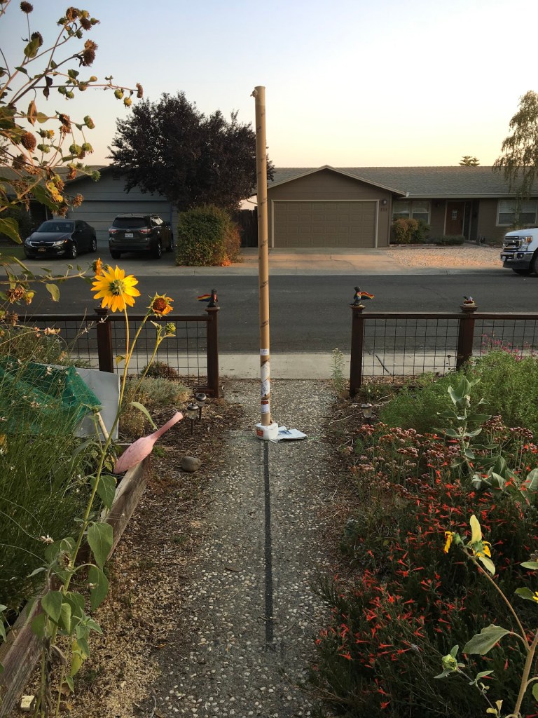
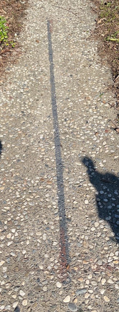
First, one must find the true north-south line, which defines the local meridian. I originally drew the black line coinciding with the shadow of a perpendicular plumb line on solar noon, 7/26/2021.
Shadows are short in the summer, and I checked it again on 12/10/21. It was not exact and I corrected it with the brown line. This proved reliable on subsequent days.
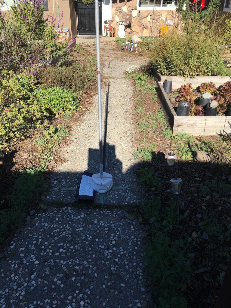
Next, a tall, perpendicular pole was erected in the daytime to prepare to measure the star that night. Its shadow at solar noon correlated well with the established N-S line. See Lead Photo.
To avoid aberration from refraction of the atmosphere, which is a lot at low altitudes*, a star should be over 15° above the horizon and bright enough to be easily seen through urban light pollution. The greater the elevation, the less aberration, but also the taller the pole, making keeping it perpendicular more difficult, so a star >15° and <45° elevation is optimal.
As outlined by the EAAE project, to measure longitude and latitude, one must set up a scope to measure the elevation and time of transit of a known star. Boninsegna attributes this method to Thales of Milet (ca. 590 BCE).
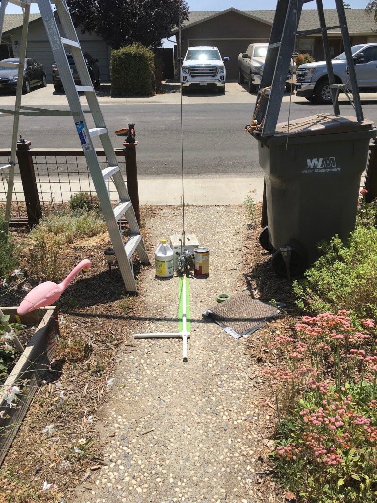
The instrument used by surveyors that measures precise angles from the horizontal to the vertical is called a theodolite. I made my theodolite from a cardboard tube attached to my spotting scope. I made crosshairs out of string; the Airy Transit Telescope used crosshairs made from spider webs.
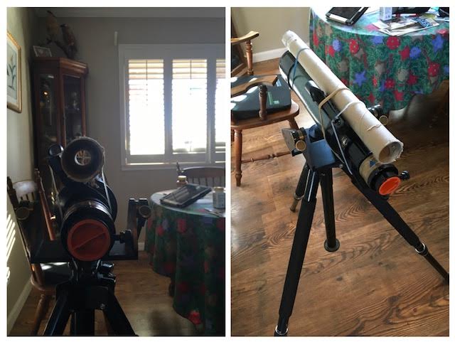
My front sidewalk slopes, so I used a trough with water inside to compute the slope. In retrospect, I think this was a major source of error.
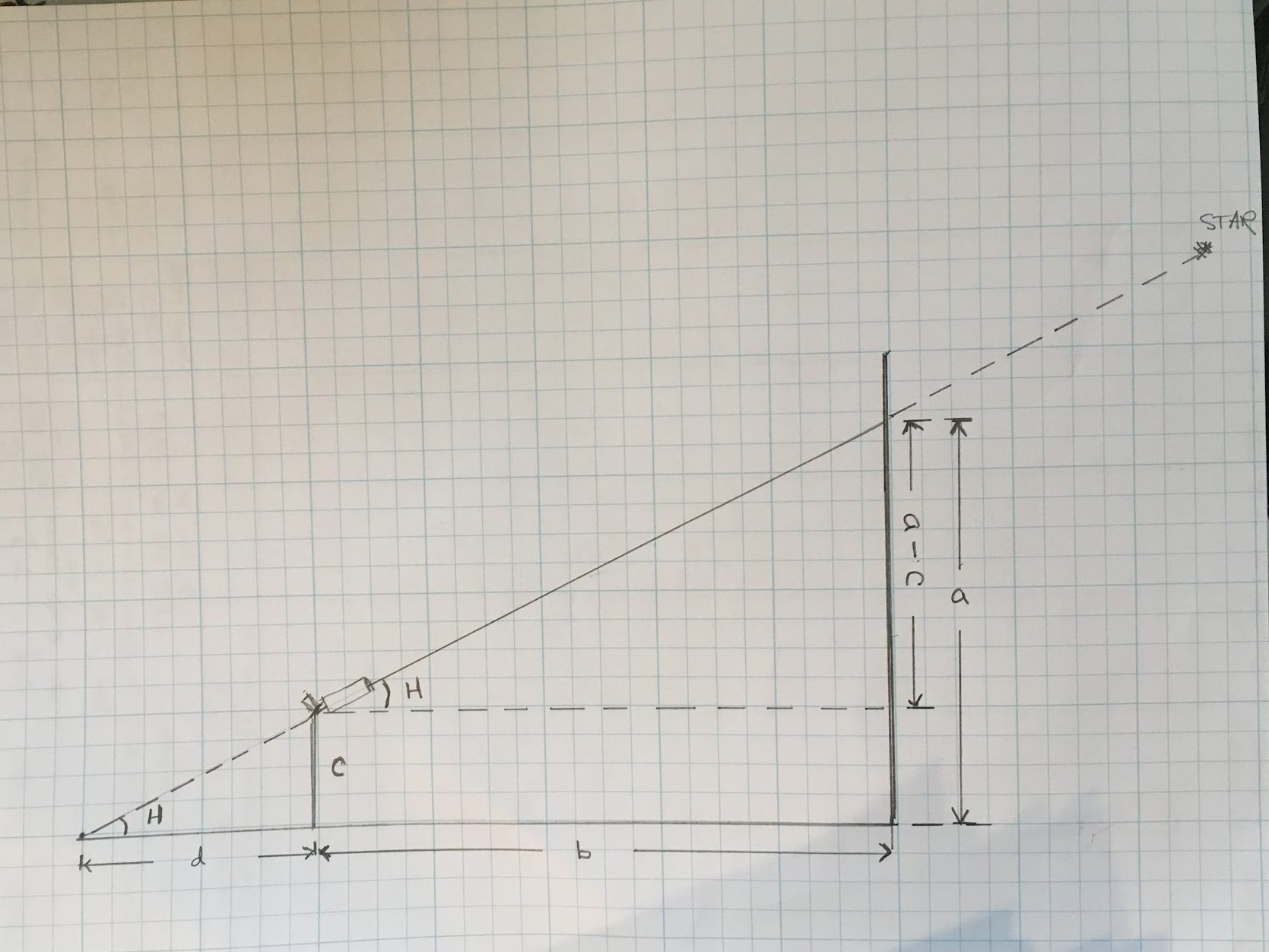
My first attempt was to measure the transit of Fomalhaut, the loneliest star, on 12/10/2021. Unfortunately, by the time I had adjusted everything, the star had already moved behind the pole and I was unable to obtain T1 for longitude calculations. I went ahead and measured the altitude of the star (“a” ) when it reappeared west of the pole for latitude calculations. This required my wife climbing a ladder and holding an LED candle at the same height as the star and marking the pole. The pole was taken down the next day and the mark measured, correcting for the slope of the sidewalk. This was so fraught with potential measurement errors that a precise result seemed improbable, not to mention the actual elevation of transit was hidden behind the pole. However, if done with proper care and equipment , this method can be more precise than measuring Polaris, which, recall, at best, is 0.65 degree off. For what it is worth, the calculations were:
c = eye height = .676 m a = height on pole = 1.857m – sidewalk slope correct=.218m = 1.639m
b = eye to pole = 2.546 m a – c = eye to height on pole = 0.963 m
Tan angle H = a-c/b = 0.963/2.546 = 0.3782 H = 20.72 ° = Elevation of star above horizon
Latitude Ψ = 90° – H + δ δ = declination of Fomalhaut on 1/1/2020 = -29°30’57” = -29.5167 ° (There is only about .01° difference in δ between 1/1/2020 and 12/10/2021 due to precession, so this can be ignored)
Latitude Ψ = 90° – 20.72° + (-29.517). = 39.76 ° Tan Ψ = 0.832
To correct for earth not being perfect sphere : tan Ψ¹ = 0.9933 tan Ψ
tan Ψ¹ = 0.8264
Ψ¹ = Calculated Latitude of dial = 39.57°
Actual Latitude of dial = 38.66° Δ = 0.91°
Since 1° of latitude equals approximately 69 miles on the surface of Earth, the latitude is off by about 63 miles. Subsequent measurements of latitude, using the transit of Sirius were no better: 35.87° on 1/22/22 and 36.23° on 2/5/22. The average of these three measurements is 37.22°, Δ = -1.44°.
Longitude requires only a perpendicular pole exactly on the local meridian and an accurate clock, so I thought I could do better with it.
On 1/22/2022, the best candidate was Sirius. Using the equal altitude method of measuring transit :
t1 = time star disappears behind pole = 10:39’:10” PM PST
t2= time star reappears next to pole = 10:43’:56” PM PST
t = time of transit = (t2 – t1)/2 + t1 = 10:41’33” PM PST = 6:41’33” AM GMT (this would be 1/23/22) = 6 h 41.55 min GMT
= 6.693 hours GMT. To express in degrees = 6.693h/24h x 360° = 100.395° ≈ 100.4° GMT = t = time of transit
Right ascension of Sirius on 1/1/2020 = α = 6h 46min 1.7 sec = 6.767 hr.
The right ascension table that I am using gives the RA calculated for 1/1/2020 at 12 Noon.
To adjust for the effect of precession of the Equinoxes :
Number of Julian days, NJ, including 1/1/2020, from 1/1/2020 to 1/23/2022 = 753 days
NJ = 753 – 1.5 = 751.5 **
T = number of centuries between the observation date and the year 2000 = NJ/36525 (36525 is the number of days in 100 years)
T = 751.5/36525 = .0206
The time of right ascension is the same as local sidereal time. To compute longitude, the baseline starting point for longitude, the Greenwich Prime Meridian, must also be converted to sidereal time.
θ₀ = Sidereal time at Greenwich at 0 hour UT ≈ GMT 1/23/2022 = 100.4606° + (36000.7701 T)° ***
θ₀= 100.4606° + 741.62° =842.081° 842.081° – 720° = 122.081° , reduced to an interval between 0° and 360°
That was the sidereal time at Greenwich at Midnight, 0 hr 1/23/22****. My time measurement, t , was made at 100.4° GMT; the earth has continued to spin , so this hour angle must be added to θ₀ to get the simultaneous Greenwich sidereal time at the time , t ,of my observation.
Greenwich sidereal time = θ₀ + (1.0027) t *****
α = Right ascension of Sirius on 1/1/2020 = 6 hr 46 min 1.7 sec = local sidereal time (LST) at the time of its transit.
α Sirius = 6.767 hr 6.767hr/24 hr x 360° = 101.51°
Calculated Longitude of dial = λ = Greenwich sidereal time – local sidereal time =
λ = (θ₀ + 1.0027 t) – α
Calculated λ = (122.081° + 100.67°) – 101.51° = 121.241° W
Actual λ = 121.790° W Δ = 0.55°
This is off by 0.55 degrees. I thought this was not bad, but Roland Boninsegna says, with care , you should be able to compute the longitude to within 0.1 degree. I should have used spider webs in my theodolite! So, with more care, I then measured the transit of Sirius on 2/5/2022.
t1= 9:45:20 PM PST t2= 9:47:50 PM PST t= transit time = 9:46:35 PM PST
t = 5:46:35 AM GMT on 2/6/22 = 5.776 hours
t in degrees = 5.776h/24 h x 360°= 86.64 °
NJ = numbers of days since 1/1/2020 = 767 – 1.5 = 765.5
T = centuries since 2000 = 765.5/36526 = 0.0210
θ₀ = Sidereal time at Greenwich at 0 h UT 2/6/2022 = 100.4606 + (36000.7701 x T) = 100.4606 + 756.02
= 856.48 ° – 720° = 136.481°.
Sidereal time at Greenwich at time t of my observation = θ₀ + 1.0027 t
α = Right ascension of Sirius on 1/1/2020 = 6.767 hr = 101.51° = local sidereal time
Calculated longitude of dial = λ = 136.481° + (1.0027)t – 101.51°= 136.481° + 86.874° – 101.51 = 121.845° W
Actual Longitude of dial = λ = 121.7901 W Δ = 0.055 °
One degree of longitude at latitude 38.66° N ≈ 54 miles 0.055° x 54 = 2.97 miles .
Average of the two measurements = 121.241 + 121.845 / 2 = 121.543 ° Δ = 0.247° = 13.3 miles
__________________________ __________________________ ___________________
Measuring the transits of hundreds of stars is the method that astronomer Charles Mason and surveyor Jeremiah Dixon used from 1765-1767 to measure their famous line . Across forests, rivers, hills, and dales, night after night, through heat and cold, they drew the line, approximately latitude 39° 48’ 15”, for 233 miles, defining the then disputed boundary of Pennsylvania and Maryland . They traveled west until their Iroquois guides refused to go further, having entered rival Lenape territory. Astronomers are a plucky bunch. They also measured north-south , making the first accurate measurement of a degree of latitude in North America. They were tasked with the latitude measurement by the Royal Society of London. Their measurement, within 0.13% of the accepted value, was the first evidence that the earth is not a perfect sphere, but an oblate spheroid, as postulated by Isaac Newton. Their measurements were incredibly accurate. I was thrilled to get within 14 miles; their maximum errors of longitude and latitude were almost always less than 800 feet.
In analyzing the scatter of their multiple computation points, they realized there was a slight deviation of their theodolites’ plumb bobs to the west. They surmised this was from the gravitational pull on their plumb lines and liquid in their levels by the Allegheny Mountains ! This then led to the famous Schiehallion experiment, which confirmed Newton’s inverse square law of gravitation and proved that the earth was solid, likely with a molten metallic core. The book Drawing the Line, by Edwin Danson, is a fascinating account of the Mason-Dixon survey.
Unlike my cardboard tubes , rubber bands, and string, their equipment was the finest in the world, including an astronomical transit (since Mason-Dixon times theodolites in the USA are often called transits) made by John Bird in London in 1760, accurate in measuring angles to within two arc seconds (0.00056 °). Their clock was accurate to within one second a day. The Bird transit stayed in the then British colonies after Mason and Dixon returned to England , and was last used in the field in 1764 in surveys of Western Pennsylvania.
It then disappeared. In 1912, it was found, during renovations, under the floor boards of the bell tower of Independence Hall, where it had been hidden 135 years prior to protect it from the British, who had occupied Philadelphia in 1777. Fully restored, it now is displayed in Independence Hall, Philadelphia, PA. It is one of greatest scientific instruments of its time, and one of the most famous tools loaned out but never returned.

_____________________________ ____________________________
_____________________________ ____________________________
- When the lower edge of the sun touches the horizon at sunset, the true center of the sun is actually 34 arc minutes = .566 ° degrees below the horizon .
** 1.5 is subtracted to align the “total days elapsed” to the standard epoch J2000.0 , which begins at 12:00 Noon UTC, not Midnight. A 0.0 day value for Julian Date year 2000 starts at Noon on January 1, 2000. This allows all astronomical observations during one night be on the same calendar date. If calculating total days elapsed from a midnight-based civil calendar, January 0 hr 0 min 2000, is the same as Midnight, December 31, 1999 (because Julian day 12/31/99 begins at 12:00 Noon 12/31/1999 and goes to 12 Noon 1/1/2000) , so 1.5 days is subtracted from the total. If using a Julian Calendar, only 0.5 days is subtracted.
*** If you called the Airy Telescope attendant on 1/1/2000, at 0 hour GMT, and asked them what time it was on their sidereal clock, they would tell you, “Greenwich sidereal time is 100.4606° = 6hr 41 min 51.5 sec.” This is the base hour angle that defines the position of the March equinox (First Point of Aries) relative to the 0° Prime Meridian at Greenwich. But recall that the sidereal clock gains on solar time. To adjust for this, one must add 36,000.77° ≈ 2,400.05 hours every Julian century = T to solar time. Since the Earth is revolving around the sun as it rotates on its axis it takes about 4 more minutes to return to it local meridian each day relative to the distant stars. In one year, the Earth completes one more sidereal rotation than solar rotations . In one Julian Century this is 100 rotations = 360° x 100 = 36,000°. The extra 0.7701° per 100 years is the effect of Precession of the Equinoxes.
**** 0 hr GMT 1/23/22 is between 11:59 PM GMT 1/22/22 and 12:01 AM GMT 1/23/22. You can see how astronomers want to have before and after midnight and midnight itself the same date.
***** 1.0027 is a correction factor in adjusting mean solar time to sidereal time because the Earth rotates ≈ 1.0027 times faster relative to the stars than to the sun.

Leave a comment